Iceland’s awe-inspiring landscape testifies to the power of nature
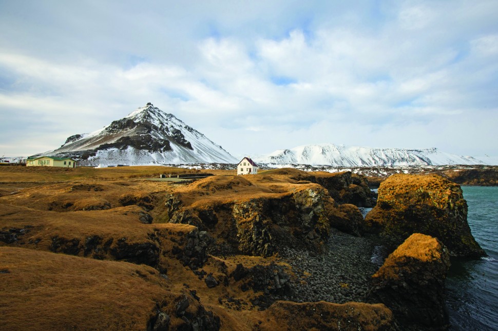
It was around 24 million years ago that Iceland first rose from the ocean as a collection of volcanoes spewing lava and gas. Perched atop the rift between the divergent North American and Eurasian tectonic plates, the environment of this north Atlantic island is today still wrought by fire, ice and a tempestuous climate. Eruptions, earthquakes, mud pools, fumaroles and spouting geysers are all part of daily Icelandic life.
_970_614.jpg)
Indeed, flying over Reykjavik, it still seems remarkable that anyone could call this seemingly inhospitable place home. Yet today the pint-sized Icelandic capital sits at the edge of the Arctic Circle with a pugnacious defiance that would make its Viking founders proud, while Icelanders across this primal land revel in its dramatic beauty.
.jpg)
Every winter many Icelandic residents and visitors retreat to cosy bars, cafes and hotel rooms while gale-force Arctic winds buffet walls and windows. Yet the very name of this wild and elemental country evokes such potent images that it challenges visitors to explore. For those who go beyond Reykjavik's city limits, some memorable sights await.
Three of Iceland’s most popular destinations are conveniently within easy reach of Reykjavik – Gullfoss, Geysir and Thingvellir – which together form what’s known locally as the Golden Circle. This 300-kilometre round trip takes in gushing geysers, thundering glacial waterfalls and one of only two places in the world where two divergent tectonic plates can easily be observed above sea level. It's the perfect introduction to the jaw-dropping, frequently surreal natural sights that seem to abound in this small country.
.jpg)
One of Iceland’s most famous attractions, Geysir has given its name to geysers the world over. While the main geyser on the site hasn’t erupted for years, today its smaller yet still impressive cousin Strokkur dutifully shoots a stream of boiling hot water and steam up to 30 metres into the air every seven minutes. If you can tolerate the sulphurous stench, there’s a panoply of other smaller geysers nearby, hissing, spitting and bubbling away like miniature cauldrons.
.jpg)
“Geysir once shot water into the air to heights of 80 metres,” explains local Hjordis Reynisdottir. “In the 1950s, however, tourists blocked it by throwing rocks into it. Luckily Strokkur is still regular as clockwork. If you're coming in winter make sure to bring gloves – when you wait seven minutes for an eruption, bodily extremities can get a bit cold.”
.jpg)
A short drive from Geysir, the location of Gullfoss (‘golden falls’) is given away by the rising clouds of spray, which are visible for kilometres around. This massive, beautiful waterfall – created by millions of gallons of glacial meltwater plunging into a deep crevice – was once endangered by a proposed power station. A local woman threatened to throw herself down the falls in protest, and Gullfoss was rescued.
The last site on a Golden Circle route is Thingvellir, a UNESCO World Heritage site where the Vikings established the world’s first democratic parliament in AD 930. This is the only place where the Mid-Atlantic tectonic plate boundary is visible on land, with valley walls drifting further apart by 7 mm each year. On a windswept winter's day, walking amongst the site's jagged boulders and soaring rock walls, it's not hard to imagine Viking chieftains convening here to settle disputes and recount ancient sagas.
.jpg)
Gaze northwest from Reykjavik on a clear day and those with eagle-eyed vision will spy the gleaming Snaefellsjokull Glacier on the horizon. While the glacier is nowhere near the size of Iceland’s largest ice sheets, it is by far the most mysterious and popular. Sitting near the tip of one of Iceland’s most beloved landscapes – the Snaefellsnes Peninsula – this is the glacier that French author Jules Verne chose as his doorway into inner space in Journey to the Centre of the Earth.
.jpg)
One of the reasons why Icelanders love the Snaefellsnes Peninsula so much (aside from its enchanting landscape brimming with lava caves, waterfalls, and mineral hot springs) is that it is a veritable heartland of history. Some of the country's best and most important sagas took place here, and it is said that explorer Christopher Columbus once spent a winter in Ingjaldsholl, where he heard stories of lands far to the west.
_970_622.jpg)
With its glistening white cone, Snaefellsjokull is the most potent and enduring symbol of Snaefellsnes. But even if the glacier weren't there, the manifold wonders of Snaefellsnes would still stand out. With its lush fjords, haunting volcanic peaks, dramatic sea cliffs, sweeping golden beaches and crooked, crunchy lava flows, the 100-kilometre-long peninsula is renowned across Iceland as the place to witness the whole country ‘in miniature’.
_970_1454.jpg)
The gateway to the north coast of the Snaefellsnes Peninsula, Grundarfjordur is the most picturesque town in the area. Kirkjufell, its oblong signature mountain, pokes up from a promontory to the west like an upturned loaf of bread, while a network of hiking trails lead south across the peninsula's mountainous spine.
During winter, the Snaefellsnes Peninsula is graced by two of the natural world’s most impressive phenomena – large groups of killer whales (or orca), and regular appearances of the iconic Aurora Borealis, or Northern Lights. When these twin attractions appear both day and night, it can be difficult finding time to sleep.
.jpg)
From mid-December to early April, the waters just off Grundarfjordur teem with herring, attracting large pods of killer whales, dolphins, porpoises and a multitude of sea birds. A number of Reykjavik-based companies run whale-watching tours, with several in Grundarfjordur itself.
.jpg)
“Whales are found in all the world's oceans, and about a quarter of all species are found in the waters around Iceland and the United Kingdom,” explains Iceland-based marine biologist and whale guide Alexa Kershaw.
“Around Iceland, the warm waters of the Gulf Stream mix with the cooler coastal currents, creating an abundance of plankton and fish, and therefore food for the whales. The best time for sightings is between October and March, when herrings come close to the fjords of the Snaefellsnes Peninsula to shelter from the worst of the winter weather. The killer whales naturally follow them, sometimes into really shallow water. You can frequently see them just by standing on the shore.”
.jpg)
Iceland is a country of natural juxtapositions. Lifeless glaciers sit above verdant valleys, while barren lava fields are bordered by gorgeous black sand beaches. Nothing seems to make sense, but it all fits together perfectly.
One Icelandic journey where the environment constantly changes is that to Jokulsarlon, a glacial lagoon around 380 kilometres east of Reykjavik. From volcanic ash deserts to moss-carpeted boulders that stretch toward the horizon, the drive to Jokulsarlon offers scenery unlike anywhere else on Earth. Soaring peaks rear up suddenly from flat, prairie-like fields, while countless waterfalls drop over huge cliffs right beside the road.
.jpg)
Jokulsarlon itself is one of the most beautiful sights of Iceland. Situated at the south end of the Vatnajokull glacier, the lake first appeared in 1934 due to glacial melting and now covers 25 square kilometres. With approximately 500 square metres of ice breaking off the glacier every year, the lagoon is filled with icebergs of all shapes and sizes. As these reflect the sky above, the whole site becomes a kaleidoscope of icy hues.
Today, many of Iceland's time-pressed travellers never get to witness the glaciers, geysers, erupting volcanoes or bubbling mud pools that continue to shape the nation's very existence. For those prepared to journey further and deeper, this dynamic land leaves memories as powerful as the landscapes that inspire them.
